
De Beque Canyon is the 10 mile stretch of Interstate 70 that runs north to south along the Colorado River from the town of De Beque, Colorado cutoff to the entrance of Palisade, Colorado.
It’s a pretty, curvy section of interstate with tunnels, gorgeous views of the Colorado River below, and red sandstone walls rising above the many cars passing by.
Around half-way through the canyon, Exit 49 leads you to Highway 65 and the Grand Mesa Scenic Byway and to Powderhorn Ski Area.
Driving south towards Palisade, on the west side of the canyon is the James Robb Colorado River State Park, which offers RV and camping sites along the river.
A little further down (also on the west side), is a turn off to the Cameo Shooting and Education Complex, which has a shooting range, and offers gun safety classes.
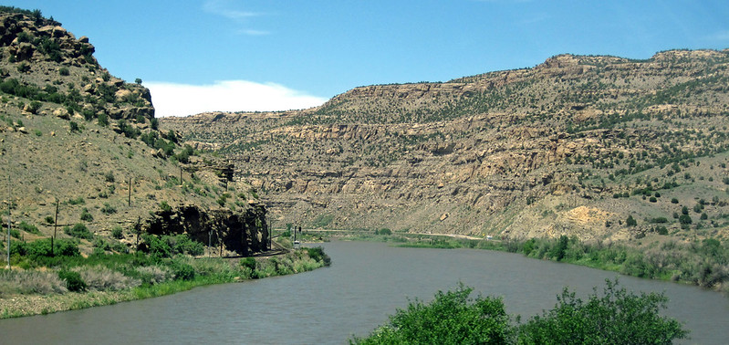
(Here is the stretch of I-70 that goes through De Beque Canyon)
This is also the road that will eventually lead you to the Little Bookcliffs wild horses range, where you can see…wild horses! This however, isn’t a quick road stop. The road turns to dirt and is rough, so hiking is often necessary to see the horses.
There are three CDOT webcams in De Beque Canyon. This one shows the northernmost part of it going. It refreshes every five minutes.
Live East Palisade Webcam (CDOT – I-70 MP 44.20 EB)
Source: CDOT COtrip
Still a little down the interstate you’ll find a cute little store called the Kokopelli Farm Market, where you can pick up some world-famous (at least to us), Palisade peaches.
Otherwise, staying on the interstate takes you west into Palisade, Grand Junction and further points west.
De Beque Canyon Drive
After the 75 mile per hour speed limits on either side of De Beque Canyon, the road can fool you into a false sense of security, so be aware there are some very sharp curves here. The speed limit drops significantly in parts here, with the yellow recommended limits going down to 45 miles on some curves, (if I remember correctly).
This webcam below is just outside the Beavertail Mountain Tunnel, right before you get to the Exit 49 exit.
Live Palisade Webcam (CDOT – Palisade Area)
Source: CDOT COtrip
Being a canyon, and in Colorado, there can always be very slick spots and black ice in areas where the snow doesn’t completely melt, so be careful.
Either way, the drive through De Beque typically isn’t very crowded.
Palisade, Colorado Webcam
While there isn’t a webcam right in Palisade, there is one located 2 miles northeast of downtown Palisade on Interstate 70 as you go into De Beque Canyon.
It’s an official Colorado Department of Transportation (CDOT) traffic webcam, located right on I-70, just over the bridge going over the Colorado River. This camera faces east, and refreshes every 90 seconds.
Here is the Palisade Highway Webcam below.
Live Grand Junction Webcam (CDOT – I-70 MP 26.50 EB)
Source: CDOT COtrip
The dam you see on the upper left-hand side of the webcam is the Grand Valley Diversion Dam.
As mentioned above, the town of Palisade doesn’t operate any highway or traffic webcams, so this is the closest one.
Grand Junction and other areas on I-70 have lots of traffic cams, but this camera is good for showing conditions a little east of Grand Junction, as Palisade weather can change faster than the rest of the valley, especially with wind and storms coming off the Grand Mesa.
It’s also a good one to check out weather in Debeque Canyon, which, in the winter, can get a little icy and a little crowded in the morning and late afternoon with skiers going to Powderhorn. In other months, this section of I-70 can get busier if there is an event on the Grand Mesa (like people driving to check out fall colors).
Other Palisade Highway Webcams
This Palisade camera above points north, towards the mountain corridor and onto Denver. The camera facing towards Palisade, (to the south over the Colorado River) isn’t online as of this writing.
I’m not entirely clear, but the south-facing traffic cam near Palisade may be one of the 136 cameras that were shut down in our state, when Colorado transportation officials ended their contract with a third-party vendor. The story is here: KJCT
Cameras are scheduled to be replaced, and I’ll try to update this article and embed that new I-70 webcam when it goes online.
Other
- Some of the canyon wall contain ancient petroglyphs that are hundreds of years old. It is believed these were drawn by the Fremont Indians.
- The road goes slightly downhill from north to south, as the town of De Beque is at 4,954 feet, while the elevation of Palisade is 4,718 feet above sea level.
- The south entrance into De Beque Canyon is 15 miles east of Grand Junction.
(By Steve Beauregard. Top photo courtesy of James St. John via Flickr.)